Geolocate

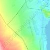
El Quseir topographic map

Click on the map to display elevation.

About this map
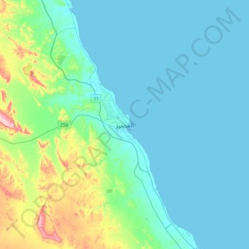
Name: El Quseir topographic map, elevation, terrain.

Location: El Quseir, Red Sea, 84712, Egypt (25.94484 34.11976 26.26484 34.43976)

Average elevation: 69 m

Minimum elevation: 0 m

Maximum elevation: 445 m

Other topographic maps

Click on a map to view its topography, its elevation and its terrain.
Al Qusair City

Egypt > Red Sea

Average elevation: 47 m

Al Qusair City

Egypt > Red Sea

Average elevation: 47 m

Industrial Area

Egypt > Red Sea

Average elevation: 38 m

Gulf of Suez

Egypt > Red Sea

Average elevation: 481 m

Wadi Allaqi

Egypt > Red Sea

Average elevation: 377 m

Marsa Alam City

Egypt > Red Sea

Average elevation: 19 m

Gulf of Suez

Egypt > Red Sea

Average elevation: 481 m

Geziret Tubya

Egypt > Red Sea > Safaja

Average elevation: 0 m

Al Hadaba

Egypt > Red Sea

Average elevation: 41 m

Gamsha

Egypt > Red Sea

Average elevation: 47 m

Wadi Gemal

Egypt > Red Sea

Average elevation: 374 m

Al Hadaba

Egypt > Red Sea

Average elevation: 41 m

Safaja

Egypt > Red Sea

Average elevation: 1 m

Industrial Area

Egypt > Red Sea

Average elevation: 38 m

Gulf of Suez

Egypt > Red Sea

Average elevation: 481 m

Gear up for your next adventure:

🧥Softshell Hiking Jacket - The perfect balance of wind protection and breathability
🔭Outdoor Binoculars - Lightweight binoculars for birdwatching and hiking
🧰Emergency Multi-Tool - Compact multi-tool for outdoor survival
🧣Evaporative Cooling Towel - Beat the heat during intense summer climbs
⛺Camping Tent - Weather-resistant tents suitable for 2 to 6 people

As an Amazon Associate, this site earns from qualifying purchases at no extra cost to you.