
Trout Lake Township topographic map
Interactive map
Click on the map to display elevation.
About this map
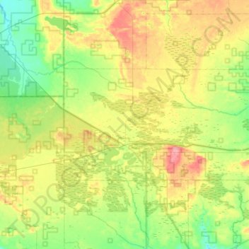
Name: Trout Lake Township topographic map, elevation, terrain.
Average elevation: 254 m
Minimum elevation: 212 m
Maximum elevation: 317 m
Other topographic maps
Click on a map to view its topography, its elevation and its terrain.
Drummond Township
United States > Michigan > Chippewa County
Drummond Township, Chippewa County, Michigan, 49726, United States
Average elevation: 181 m
Sault Ste. Marie
United States > Michigan > Chippewa County > Sault Ste. Marie
Sault Ste. Marie, Chippewa County, Michigan, 49783-3602, United States
Average elevation: 198 m
Marl Lake
United States > Michigan > Chippewa County > Drummond Township
Marl Lake, Drummond Township, Chippewa County, Michigan, United States
Average elevation: 205 m