
Sóc Sơn District topographic map
Interactive map
Click on the map to display elevation.
About this map
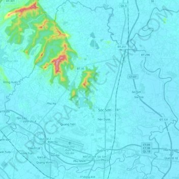
Name: Sóc Sơn District topographic map, elevation, terrain.
Location: Sóc Sơn District, Hà Nội, Vietnam (21.17692 105.72319 21.38528 105.93922)
Average elevation: 28 m
Minimum elevation: 2 m
Maximum elevation: 446 m
Other topographic maps
Click on a map to view its topography, its elevation and its terrain.