Geolocate

Friesenheim topographic map

Click on the map to display elevation.

About this map

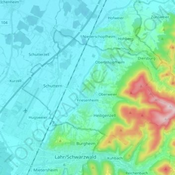
Name: Friesenheim topographic map, elevation, terrain.

Location: Friesenheim, Ortenaukreis, Baden-Württemberg, 77948, Germany (48.34584 7.82196 48.41655 7.98279)

Average elevation: 216 m

Minimum elevation: 142 m

Maximum elevation: 603 m

Other topographic maps

Click on a map to view its topography, its elevation and its terrain.

Schliffkopf

Germany > Baden-Württemberg > Ortenaukreis > Oppenau

Average elevation: 864 m

Waldulm

Germany > Baden-Württemberg > Ortenaukreis

Average elevation: 287 m

Hilsenhof

Germany > Baden-Württemberg > Ortenaukreis > Seebach

Average elevation: 529 m

Einach

Germany > Baden-Württemberg > Ortenaukreis > Gengenbach > Einach

Average elevation: 256 m

Gear up for your next adventure:

🥾Mountaineering Boots - Supportive boots for climbing and high-altitude hiking
🧥Waterproof Jacket - Lightweight rain jackets for hiking and outdoor activities
🧢Beanie Hat - Keep your head warm in cold weather
🛶Kayak Dry Bag - Waterproof storage for kayaking adventures
🐕Hiking Dog Pack - Let your canine companion carry their own water and food

As an Amazon Associate, this site earns from qualifying purchases at no extra cost to you.