Geolocate

Case-Pilote topographic map

Click on the map to display elevation.

About this map

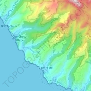
Name: Case-Pilote topographic map, elevation, terrain.

Location: Case-Pilote, Saint-Pierre, Martinique, 97222, France (14.62799 -61.15402 14.69085 -61.10538)

Average elevation: 204 m

Minimum elevation: -1 m

Maximum elevation: 876 m

Other topographic maps

Click on a map to view its topography, its elevation and its terrain.

Grosse Roche

France > Martinique > Le Morne-Rouge

Average elevation: 394 m

Épineux

France > Martinique > Sainte-Marie

Average elevation: 64 m

Gear up for your next adventure:

🥾Lightweight Hiking Boots - Boots for comfort and mobility on long hikes
🧭GPS Tracker - Track your location in remote areas safely
🧰Survival Kit - Essential gear for emergencies in the wilderness
Lightweight Camping Tent - Portable shelter optimized for Canadian backcountry camping
👟Sport Hiking Sandals - Breathable footwear for water crossings and camp rest

As an Amazon Associate, this site earns from qualifying purchases at no extra cost to you.