
Make a donation
Gear up for your next adventure:
As an Amazon Associate, this site earns from qualifying purchases at no extra cost to you.
Arches National Park topographic map
Click on the map to display elevation.
Make a donation
Gear up for your next adventure:
As an Amazon Associate, this site earns from qualifying purchases at no extra cost to you.
Arches National Park
The park consists of 310.31 km2 (76,680 acres; 119.81 sq mi; 31,031 ha) of high desert located on the Colorado Plateau. The highest elevation in the park is 5,653 ft (1,723 m) at Elephant Butte, and the lowest elevation is 4,085 ft (1,245 m) at the visitor center. The park receives an average of less than 10 in (250 mm) of rain annually.
Make a donation
Gear up for your next adventure:
As an Amazon Associate, this site earns from qualifying purchases at no extra cost to you.
About this map
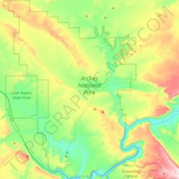
Name: Arches National Park topographic map, elevation, terrain.
Location: Arches National Park, Grand County, Utah, United States (38.60474 -109.71320 38.84693 -109.47771)
Average elevation: 1,476 m
Minimum elevation: 1,206 m
Maximum elevation: 1,995 m
Make a donation
Gear up for your next adventure:
As an Amazon Associate, this site earns from qualifying purchases at no extra cost to you.