
Make a donation
Gear up for your next adventure:
As an Amazon Associate, this site earns from qualifying purchases at no extra cost to you.
Istanbul topographic map
Click on the map to display elevation.
Make a donation
Gear up for your next adventure:
As an Amazon Associate, this site earns from qualifying purchases at no extra cost to you.
Istanbul
Istanbul, located in northwestern Turkey, is a city that is uniquely situated across two continents, Europe and Asia, divided by the Bosphorus Strait. The city’s topography is characterized by a complex blend of hills, valleys, and coastal plains, which create a varied and scenic landscape. The European side of Istanbul is marked by the presence of several hills, such as the famous seven hills that shape the historic skyline, with the highest being Çamlıca Hill on the Asian side offering panoramic views. Beyond these, the city's terrain includes higher elevations, with Aydos Hill reaching 537 meters (1,762 feet), making it the highest point in Istanbul. The city is bordered by the Sea of Marmara to the south and the Black Sea to the north, providing a rugged, undulating coastline with natural harbors like the Golden Horn. The land rises dramatically in some areas, especially in the central and northern parts, giving rise to a dramatic, hilly terrain in many districts. This topographical diversity influences the urban development and lifestyle of the city, with steep streets, scenic viewpoints, and natural surroundings adding to its beauty and historical appeal.
Make a donation
Gear up for your next adventure:
As an Amazon Associate, this site earns from qualifying purchases at no extra cost to you.
About this map
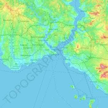
Name: Istanbul topographic map, elevation, terrain.
Location: Istanbul, Fatih, Istanbul, Marmara Region, 34122, Turkey (40.84638 28.81587 41.16638 29.13587)
Average elevation: 57 m
Minimum elevation: -2 m
Maximum elevation: 429 m
Make a donation
Gear up for your next adventure:
As an Amazon Associate, this site earns from qualifying purchases at no extra cost to you.
Other topographic maps
Click on a map to view its topography, its elevation and its terrain.