
Huntsville topographic map
Click on the map to display elevation.
Huntsville
Huntsville lies in the Tennessee Valley, where broad lowlands meet the western escarpments and outliers of the Cumberland Plateau. The city’s central and western areas occupy relatively flat to gently rolling valley terrain, while the eastern and southeastern skyline rises abruptly toward Monte Sano, Green Mountain, Keel Mountain, and other wooded uplands. This contrast creates a varied relief pattern: lower urban plains and creek corridors spread across the valley floor, while steep slopes, narrow coves, and plateau-like summits climb to more than 1,600 ft (488 m), giving Huntsville a landscape of open valley basins framed by rugged, forested mountain edges.
About this map
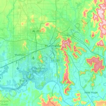
Name: Huntsville topographic map, elevation, terrain.
Location: Huntsville, Madison County, Alabama, United States (34.53343 -86.95678 34.86516 -86.39934)
Average elevation: 232 m
Minimum elevation: 166 m
Maximum elevation: 546 m
Other topographic maps
Click on a map to view its topography, its elevation and its terrain.