Geolocate

Minneapolis topographic map

Click on the map to display elevation.

Minneapolis

A 1959 report by the U.S. Soil Conservation Service listed Minneapolis's elevation as 830 feet (250 m). The city's lowest elevation of 687 feet (209 m) above sea level is near where Minnehaha Creek meets the Mississippi River. Sources disagree on the exact location and elevation of the city's highest point, which is cited as being anywhere from 965–985 feet (294–300 m) above sea level.

About this map

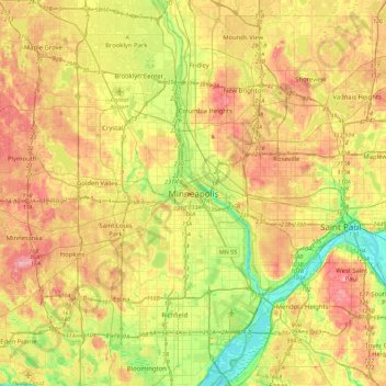
Name: Minneapolis topographic map, elevation, terrain.

Location: Minneapolis, Hennepin County, Minnesota, 55488, United States (44.81730 -93.42547 45.13730 -93.10547)

Average elevation: 271 m

Minimum elevation: 209 m

Maximum elevation: 338 m

Other topographic maps

Click on a map to view its topography, its elevation and its terrain.

Regina

United States > Minnesota > Hennepin County > Minneapolis

Average elevation: 263 m

Gear up for your next adventure:

🧦Hiking Socks - Moisture-wicking and comfortable socks for long hikes
🛏️Camping Sleeping Mat - Comfortable mats for sleeping outdoors
🧶550 Survival Paracord - Versatile utility cord for emergency repairs and rigging
🧤Thermal Hiking Gloves - Grip-enhanced gloves for cold-weather altitude trekking
🕶️Polarized Sunglasses - Reduces glare from snow and water at high elevations

As an Amazon Associate, this site earns from qualifying purchases at no extra cost to you.