Geolocate

Tabio topographic map

Click on the map to display elevation.

About this map

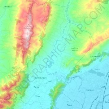
Name: Tabio topographic map, elevation, terrain.

Location: Tabio, Sabana Centro, Cundinamarca, 0000, Colombia (4.89268 -74.13172 5.01121 -74.03616)

Average elevation: 2,772 m

Minimum elevation: 2,548 m

Maximum elevation: 3,329 m

Gear up for your next adventure:

🥾Trekking Boots - Durable boots for long-distance trekking
💧Filtered Water Bottle - Safe drinking water on the go
🧥Waterproof Pants - Keep dry during rainy hiking conditions
🛁Quick-Dry Microfiber Towel - Space-saving towel that dries rapidly on the move
Camping Coffee Maker - Brew fresh coffee anywhere on the topographic map

As an Amazon Associate, this site earns from qualifying purchases at no extra cost to you.