
Make a donation
Gear up for your next adventure:
As an Amazon Associate, this site earns from qualifying purchases at no extra cost to you.
Lanquín topographic map
Click on the map to display elevation.
Make a donation
Gear up for your next adventure:
As an Amazon Associate, this site earns from qualifying purchases at no extra cost to you.
Lanquín
San Agustín Lanquín (Spanish pronunciation: [san aɣusˈtin laŋˈkin]), often referred to simply as Lanquín, is a municipality in the Guatemalan department of Alta Verapaz. It lies at an altitude of 380 m (1,250 ft) above sea level. It has a population of about 16,500 people, many of Q'eqchi' Maya descent. It covers an area of 208 km².
Make a donation
Gear up for your next adventure:
As an Amazon Associate, this site earns from qualifying purchases at no extra cost to you.
About this map
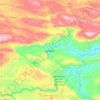
Name: Lanquín topographic map, elevation, terrain.
Location: Lanquín, Alta Verapaz, 11307, Guatemala (15.48936 -90.06953 15.66325 -89.90632)
Average elevation: 756 m
Minimum elevation: 170 m
Maximum elevation: 1,463 m
Make a donation
Gear up for your next adventure:
As an Amazon Associate, this site earns from qualifying purchases at no extra cost to you.
Other topographic maps
Click on a map to view its topography, its elevation and its terrain.