Geolocate

Puerto Real topographic map

Click on the map to display elevation.

About this map

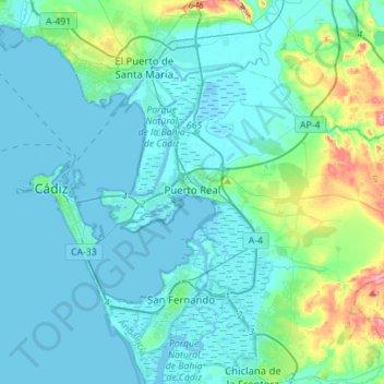
Name: Puerto Real topographic map, elevation, terrain.

Location: Puerto Real, Bay of Cádiz, Cádiz, Andalusia, Spain (36.45579 -6.25911 36.59939 -5.98013)

Average elevation: 18 m

Minimum elevation: -7 m

Maximum elevation: 123 m

Gear up for your next adventure:

👟Sport Hiking Sandals - Breathable footwear for water crossings and camp rest
🧴Insect Repellent - Protect yourself from bugs during outdoor adventures
Tent Footprint - Protect tent floor and increase durability
🥾Waterproof Hiking Shoes - Durable shoes for wet and rugged trails
🥾All-Terrain Hiking Boots - Versatile boots for varied hiking conditions

As an Amazon Associate, this site earns from qualifying purchases at no extra cost to you.