
Alcorcón topographic map
Click on the map to display elevation.
Alcorcón
The municipality, largely flat, lies at an average altitude of 711 metres above sea level, with the highest point being El Ventorro del Cano (741 m), located in the north of the municipality.
About this map
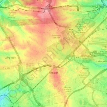
Name: Alcorcón topographic map, elevation, terrain.
Location: Alcorcón, Community of Madrid, Spain (40.32394 -3.87879 40.40310 -3.78792)
Average elevation: 692 m
Minimum elevation: 634 m
Maximum elevation: 742 m
Other topographic maps
Click on a map to view its topography, its elevation and its terrain.