
Make a donation
Gear up for your next adventure:
As an Amazon Associate, this site earns from qualifying purchases at no extra cost to you.
Nador Province topographic map
Click on the map to display elevation.
Make a donation
Gear up for your next adventure:
As an Amazon Associate, this site earns from qualifying purchases at no extra cost to you.
About this map
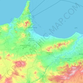
Name: Nador Province topographic map, elevation, terrain.
Location: Nador Province, Oriental, Morocco (34.66332 -3.27058 35.44014 -2.34348)
Average elevation: 206 m
Minimum elevation: -1 m
Maximum elevation: 1,193 m
Make a donation
Gear up for your next adventure:
As an Amazon Associate, this site earns from qualifying purchases at no extra cost to you.
Other topographic maps
Click on a map to view its topography, its elevation and its terrain.
Small Forest Type Land
Morocco > Cercle de Chichaoua دائرة شيشاوة > Sidi Bouzid Arragragui
Average elevation: 469 m
Make a donation
Gear up for your next adventure:
As an Amazon Associate, this site earns from qualifying purchases at no extra cost to you.
Douar Lekbir Draa Ben Chekra
Morocco > cercle de Hrara > Ahrara > Douar Lekbir Draa Ben Chekra
Average elevation: 93 m