Geolocate

Domenjod topographic map

Click on the map to display elevation.

About this map

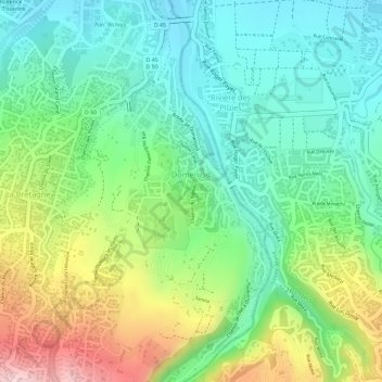
Name: Domenjod topographic map, elevation, terrain.

Location: Domenjod, Saint-Denis, Réunion, France (-20.92660 55.50189 -20.90713 55.51282)

Average elevation: 154 m

Minimum elevation: 56 m

Maximum elevation: 326 m

Gear up for your next adventure:

🧼Biodegradable Camp Soap - Environmentally friendly cleaning for gear and body
🧭Orienteering Kit - Tools for map reading and navigation in the wild
🔦LED Headlamp - Hands-free lighting for early morning starts or late finishes
🦶Hiking Shoe Insoles - Added support for high arches and long days on feet
🚲Handlebar Phone Mount - View topographic-map.com live while cycling

As an Amazon Associate, this site earns from qualifying purchases at no extra cost to you.