
Thank you for supporting this site ❤️
Make a donation
Make a donation
Gear up for your next adventure:
As an Amazon Associate, this site earns from qualifying purchases at no extra cost to you.
Lac-Mégantic topographic map
Click on the map to display elevation.
Thank you for supporting this site ❤️
Make a donation
Make a donation
Gear up for your next adventure:
As an Amazon Associate, this site earns from qualifying purchases at no extra cost to you.
About this map
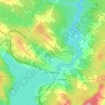
Name: Lac-Mégantic topographic map, elevation, terrain.
Location: Lac-Mégantic, Le Granit, Estrie, Quebec, Canada (45.56271 -70.94362 45.61825 -70.84427)
Average elevation: 434 m
Minimum elevation: 380 m
Maximum elevation: 536 m
Thank you for supporting this site ❤️
Make a donation
Make a donation
Gear up for your next adventure:
As an Amazon Associate, this site earns from qualifying purchases at no extra cost to you.
Other topographic maps
Click on a map to view its topography, its elevation and its terrain.
Réserve écologique du Mont-Gosford
Canada > Quebec > Le Granit > Saint-Augustin-de-Woburn
Average elevation: 877 m