
Pittsburg topographic map
Click on the map to display elevation.
Pittsburg
The highest point in Pittsburg is the summit of Stub Hill, at 3,627 feet (1,106 m). Mount Magalloway, elevation 3,383 feet (1,031 m), is a prominent summit reachable by hiking trail.
About this map
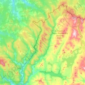
Name: Pittsburg topographic map, elevation, terrain.
Location: Pittsburg, Coös County, New Hampshire, United States (45.01345 -71.50661 45.30578 -71.05950)
Average elevation: 522 m
Minimum elevation: 291 m
Maximum elevation: 962 m
Other topographic maps
Click on a map to view its topography, its elevation and its terrain.