Geolocate

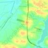
Itaitinga topographic map

Click on the map to display elevation.

About this map

Name: Itaitinga topographic map, elevation, terrain.

Location: Itaitinga, Região Geográfica Imediata de Fortaleza, Região Geográfica Intermediária de Fortaleza, Ceará, Northeast Region, Brazil (-4.12331 -38.61285 -3.85920 -38.50180)

Average elevation: 65 m

Minimum elevation: 3 m

Maximum elevation: 754 m

Other topographic maps

Click on a map to view its topography, its elevation and its terrain.
Buenos Aries

Brazil > Ceará > Alcântaras

Average elevation: 743 m

Machuca

Brazil > Ceará > Aquiraz

Average elevation: 19 m

Gear up for your next adventure:

🥽Outdoor Goggles - Protective eyewear for outdoor activities
💡Portable Camping Lamp - Rechargeable lamp for campsite lighting
🔭Compact Binoculars - Lightweight optics for scouting trails and wildlife
🧢Sun Protection Cap - Breathable cap to protect from sun exposure
🎒Backpack Rain Cover - External shield to keep your entire pack dry

As an Amazon Associate, this site earns from qualifying purchases at no extra cost to you.