
Araras topographic map
Click on the map to display elevation.
About this map
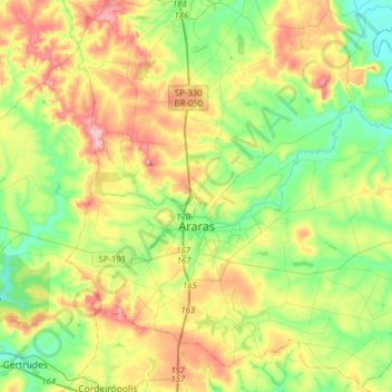
Name: Araras topographic map, elevation, terrain.
Average elevation: 658 m
Minimum elevation: 562 m
Maximum elevation: 822 m
Other topographic maps
Click on a map to view its topography, its elevation and its terrain.
Kobayat Líbano
Brazil > São Paulo > Região Metropolitana de Piracicaba > Piracicaba
Average elevation: 521 m
Nova Piracicaba
Brazil > São Paulo > Região Metropolitana de Piracicaba > Piracicaba
Average elevation: 493 m
Mirante Rio Piracicaba
Brazil > São Paulo > Região Metropolitana de Piracicaba > Piracicaba
Average elevation: 505 m