Geolocate

Andes topographic map

Click on the map to display elevation.

About this map

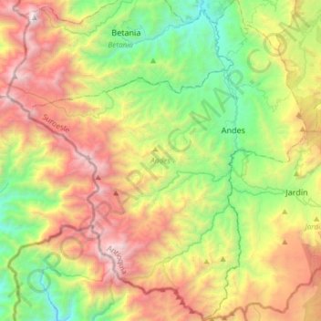
Name: Andes topographic map, elevation, terrain.

Location: Andes, Suroeste, Antioquia, Colombia (5.48064 -76.06667 5.77515 -75.81031)

Average elevation: 2,123 m

Minimum elevation: 897 m

Maximum elevation: 3,945 m

Other topographic maps

Click on a map to view its topography, its elevation and its terrain.

Piedras Blancas - Matasano

Colombia > Antioquia > Medellín

Average elevation: 2,426 m

Gear up for your next adventure:

🧥Insulated Jacket - Keep warm in cold outdoor conditions
🔋Emergency Crank Radio - Weather alerts and power without needing batteries
💡Solar Camping Lamp - Eco-friendly lighting for campsites
🥾Approach Boots - Comfortable boots for hiking and climbing approaches
🥾Trail Hiking Boots - Supportive boots for rough trails

As an Amazon Associate, this site earns from qualifying purchases at no extra cost to you.