
Make a donation
Gear up for your next adventure:
As an Amazon Associate, this site earns from qualifying purchases at no extra cost to you.
Biescas topographic map
Click on the map to display elevation.
Make a donation
Gear up for your next adventure:
As an Amazon Associate, this site earns from qualifying purchases at no extra cost to you.
Biescas
The town of Biescas is located at 875 meters altitude on the banks of the Gállego river. The municipality extends along a small plain and includes the canyon to access to the Tena Valley. At 72 km north of the main city Huesca, Biescas is a communication hub between the regions of Jacetania and Sobrarbe. The town is strategically located to crossing the Gállego river, as a link between the valleys of Tena and Ara.
Make a donation
Gear up for your next adventure:
As an Amazon Associate, this site earns from qualifying purchases at no extra cost to you.
About this map
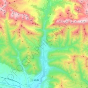
Name: Biescas topographic map, elevation, terrain.
Location: Biescas, Alto Gállego, Huesca, Aragon, Spain (42.52936 -0.43230 42.72723 -0.21201)
Average elevation: 1,472 m
Minimum elevation: 775 m
Maximum elevation: 2,826 m
Make a donation
Gear up for your next adventure:
As an Amazon Associate, this site earns from qualifying purchases at no extra cost to you.
Other topographic maps
Click on a map to view its topography, its elevation and its terrain.