Geolocate

Setcases topographic map

Click on the map to display elevation.

About this map

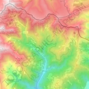
Name: Setcases topographic map, elevation, terrain.

Location: Setcases, Ripollès, Girona, Catalonia, 17869, Spain (42.36140 2.23286 42.43870 2.34620)

Average elevation: 1,972 m

Minimum elevation: 1,183 m

Maximum elevation: 2,701 m

Other topographic maps

Click on a map to view its topography, its elevation and its terrain.

Puigmal d'Err

Spain > Catalonia > Ripollès > Queralbs

Average elevation: 2,571 m

Fornells de la Muntanya

Spain > Catalonia > Ripollès

Average elevation: 1,566 m

Gear up for your next adventure:

🕯️Camping Lantern - Illuminates your entire campsite with high-efficiency LEDs
🥤Collapsible Travel Cup - Saves space and weight in your mess kit
🥾Waterproof Hiking Boots - Essential footwear for rugged terrain and wet Canadian trails
🥘Camping Cookware Set - Compact nesting pots and pans for trail cooking
🧳Compression Sacks - Maximize space in your backpack by shrinking gear

As an Amazon Associate, this site earns from qualifying purchases at no extra cost to you.