Geolocate

Harlingen topographic map

Click on the map to display elevation.

About this map
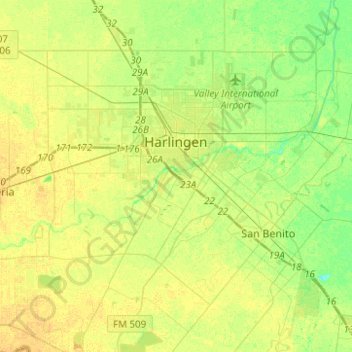
Name: Harlingen topographic map, elevation, terrain.

Location: Harlingen, Cameron County, Texas, 78550, United States (26.05712 -97.79636 26.27989 -97.61578)

Average elevation: 14 m

Minimum elevation: 2 m

Maximum elevation: 23 m

Other topographic maps

Click on a map to view its topography, its elevation and its terrain.
Laguna Heights

United States > Texas > Cameron County

Average elevation: 2 m

South Point

United States > Texas > Cameron County

Average elevation: 7 m

Arroyo City

United States > Texas > Cameron County

Average elevation: 5 m

Olmito

United States > Texas > Cameron County

Average elevation: 11 m

Palmer Colonia

United States > Texas > Cameron County

Average elevation: 15 m

Lozano

United States > Texas > Cameron County

Average elevation: 10 m

Lopez Colonia

United States > Texas > Cameron County > Rio Hondo

Average elevation: 10 m

Loma Plata

United States > Texas > Cameron County

Average elevation: 0 m

Gear up for your next adventure:

🛁Quick-Dry Microfiber Towel - Space-saving towel that dries rapidly on the move
🚲MTB Frame Bag - Carry tools and maps directly on your bicycle frame
👟Leg Gaiters - Keep debris, mud, and snow out of your boots
🧢Hiking Sun Hat - Wide-brimmed protection for exposed mountain ridges
🏕️Camping Hammock - Integrated protection for sleeping between trees

As an Amazon Associate, this site earns from qualifying purchases at no extra cost to you.