Geolocate

Palermo topographic map

Click on the map to display elevation.

About this map
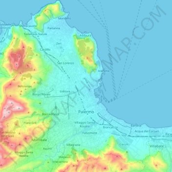
Name: Palermo topographic map, elevation, terrain.

Location: Palermo, Sicily, Italy (38.04991 13.24222 38.22459 13.45209)

Average elevation: 162 m

Minimum elevation: -1 m

Maximum elevation: 1,038 m

Other topographic maps

Click on a map to view its topography, its elevation and its terrain.
Bellacera

Italy > Sicily > Palermo > Santa Flavia

Average elevation: 162 m

Sorgente di Montescuro

Italy > Sicily > Palermo > Prizzi

Average elevation: 831 m

San Carlo

Italy > Sicily > Palermo > Chiusa Sclafani

Average elevation: 291 m

Finale

Italy > Sicily > Palermo

Average elevation: 84 m

Santa Lucia

Italy > Sicily > Palermo > Cefalù

Average elevation: 51 m

Gear up for your next adventure:

⛺Lightweight Backpacking Tent - Compact tent for efficient hiking trips
🧢Sun Hat - Wide-brim hat for sun protection
🧴Outdoor Sunscreen - High SPF protection for high-altitude UV exposure
🦯Trekking Poles - Reduced impact on joints for steep topographic climbs
🛌Down Sleeping Bag - Superior warmth-to-weight ratio for cold nights

As an Amazon Associate, this site earns from qualifying purchases at no extra cost to you.