
Make a donation
Gear up for your next adventure:
As an Amazon Associate, this site earns from qualifying purchases at no extra cost to you.
Troisdorf topographic map
Click on the map to display elevation.
Make a donation
Gear up for your next adventure:
As an Amazon Associate, this site earns from qualifying purchases at no extra cost to you.
About this map
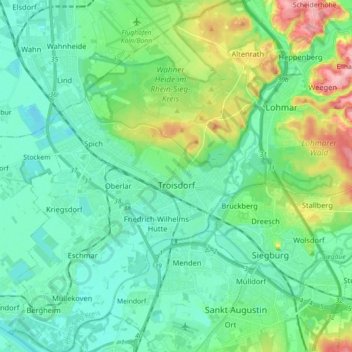
Name: Troisdorf topographic map, elevation, terrain.
Location: Troisdorf, Rhein-Sieg-Kreis, North Rhine-Westphalia, Germany (50.76156 7.07720 50.87453 7.21490)
Average elevation: 72 m
Minimum elevation: 41 m
Maximum elevation: 170 m
Make a donation
Gear up for your next adventure:
As an Amazon Associate, this site earns from qualifying purchases at no extra cost to you.
Other topographic maps
Click on a map to view its topography, its elevation and its terrain.
Meckenheim
Germany > North Rhine-Westphalia > Rhein-Sieg-Kreis > Meckenheim > Meckenheim
Average elevation: 190 m
Hommerich
Germany > North Rhine-Westphalia > Rhein-Sieg-Kreis > Hennef (Sieg) > Hofen
Average elevation: 156 m