Geolocate

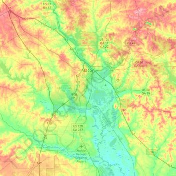
Macon topographic map

Click on the map to display elevation.

Macon

The Ocmulgee River is a major river that runs through the city. Macon is one of Georgia's three major Fall Line cities, along with Augusta and Columbus. The Fall Line is where the hills of the Piedmont plateau meet the flat terrain of the coastal plain. As such, Macon has a varied landscape of rolling hills on the north side and flat plains on the south. The fall line, where the elevation drops noticeably, causes rivers and creeks in the area to flow rapidly toward the ocean. In the past, Macon and other Fall Line cities had many textile mills powered by the rivers.

Wikipedia (CC-BY-SA 3.0)

About this map

Name: Macon topographic map, elevation, terrain.

Location: Macon, Bibb County, Georgia, United States (32.66064 -83.89272 32.95287 -83.48943)

Average elevation: 127 m

Minimum elevation: 69 m

Maximum elevation: 210 m

Other topographic maps

Click on a map to view its topography, its elevation and its terrain.

Whispering Pines

United States > Georgia > Bibb County > Macon

Average elevation: 132 m

Idlewood

United States > Georgia > Bibb County > Macon

Average elevation: 132 m

Lizella

United States > Georgia > Bibb County > Macon

Average elevation: 146 m

Lake Arrowhead

United States > Georgia > Bibb County > Macon

Average elevation: 137 m

Wood Valley

United States > Georgia > Bibb County > Macon

Average elevation: 120 m

Liberty View

United States > Georgia > Bibb County > Macon

Average elevation: 121 m

Dry Branch

United States > Georgia > Bibb County > Macon

Average elevation: 131 m

East Macon

United States > Georgia > Bibb County > Macon

Average elevation: 121 m

Bridgeman

United States > Georgia > Bibb County > Macon

Average elevation: 115 m

Lorane

United States > Georgia > Bibb County > Macon

Average elevation: 152 m

Sunnydale Acres

United States > Georgia > Bibb County > Macon

Average elevation: 113 m

Highland Circle

United States > Georgia > Bibb County > Macon

Average elevation: 118 m

Sofkee

United States > Georgia > Bibb County > Macon

Average elevation: 110 m

Unionville

United States > Georgia > Bibb County > Macon

Average elevation: 132 m

Dougherty Lake Dam

United States > Georgia > Bibb County > Macon

Average elevation: 142 m

Gear up for your next adventure:

🧴Insect Repellent - Protect yourself from bugs during outdoor adventures
🎒Fully Waterproof Backpack - Total protection for photography gear and electronics
🧥Softshell Jacket - Windproof and breathable jacket for hiking
🚲Handlebar Phone Mount - View topographic-map.com live while cycling
🔋Lithium AA Batteries - Long-lasting power that performs in extreme cold

As an Amazon Associate, this site earns from qualifying purchases at no extra cost to you.