
Make a donation
Gear up for your next adventure:
As an Amazon Associate, this site earns from qualifying purchases at no extra cost to you.
Guntur topographic map
Click on the map to display elevation.
Make a donation
Gear up for your next adventure:
As an Amazon Associate, this site earns from qualifying purchases at no extra cost to you.
Guntur
Guntur is located at 16°17′N 80°26′E / 16.29°N 80.43°E / 16.29; 80.43. It has an average elevation of 33 m (108 ft) and is situated on the plains. There are few hills in the surrounding suburban areas and Perecherla Reserve Forest on the north west. The city is around 64 km (40 mi) to the west of the Bay of Bengal on the east coast of India. The Krishna delta lies partly in the Guntur district. There are other smaller rivers and channels in the region such as Guntur Channel, Chandravanka, Naagileru, Guntur Branch Canal etc.
Make a donation
Gear up for your next adventure:
As an Amazon Associate, this site earns from qualifying purchases at no extra cost to you.
About this map
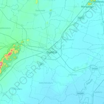
Name: Guntur topographic map, elevation, terrain.
Location: Guntur, Andhra Pradesh, 522001, India (16.13152 80.29416 16.45152 80.61416)
Average elevation: 29 m
Minimum elevation: 6 m
Maximum elevation: 474 m
Make a donation
Gear up for your next adventure:
As an Amazon Associate, this site earns from qualifying purchases at no extra cost to you.
Other topographic maps
Click on a map to view its topography, its elevation and its terrain.