Geolocate

Cananda topographic map

Click on the map to display elevation.

About this map

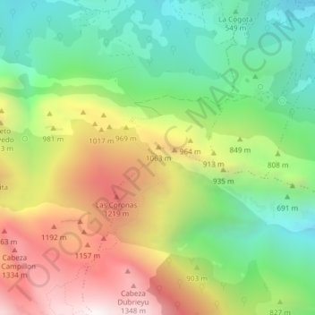
Name: Cananda topographic map, elevation, terrain.

Location: Cananda, Cabrales, Asturias, 33555, Spain (43.27873 -4.87176 43.29873 -4.85176)

Average elevation: 781 m

Minimum elevation: 294 m

Maximum elevation: 1,455 m

Other topographic maps

Click on a map to view its topography, its elevation and its terrain.

Berodia

Spain > Asturias > Cabrales

Average elevation: 864 m

Sotres

Spain > Asturias > Cabrales

Average elevation: 1,496 m

San Roque

Spain > Asturias > Cabrales

The altitude is 441 m (1,447 ft) above sea level. It is 20.87 km2 (8.06 sq mi) in size with a population of 199 (INE 2011). The postal code is 33555.

Average elevation: 737 m

Arenas

Spain > Asturias > Cabrales

Average elevation: 670 m

Gear up for your next adventure:

🔭Compact Monocular - One-handed bird watching and trail spotting
🚲Handlebar Phone Mount - View topographic-map.com live while cycling
🛁Quick-Dry Microfiber Towel - Space-saving towel that dries rapidly on the move
🧳Compression Sacks - Maximize space in your backpack by shrinking gear
❄️Traction Ice Cleats - Slip-on spikes for icy trails and winter hiking

As an Amazon Associate, this site earns from qualifying purchases at no extra cost to you.