Geolocate

Ospina topographic map

Click on the map to display elevation.

About this map

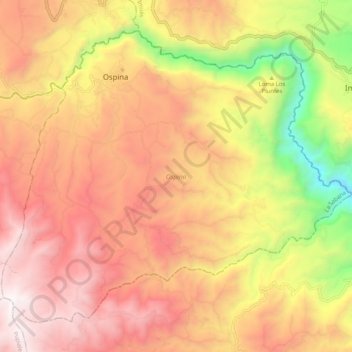
Name: Ospina topographic map, elevation, terrain.

Location: Ospina, La Sabana, Nariño, Colombia (0.98745 -77.59877 1.07196 -77.49671)

Average elevation: 2,842 m

Minimum elevation: 1,888 m

Maximum elevation: 3,513 m

Gear up for your next adventure:

🍽️Titanium Camping Spork - Ultralight and indestructible eating utensil
❄️Traction Ice Cleats - Slip-on spikes for icy trails and winter hiking
🥾Trail Hiking Boots - Supportive boots for rough trails
Lightweight Camping Tent - Portable shelter optimized for Canadian backcountry camping
🥾Light Trekking Boots - Supportive boots for multi-day treks

As an Amazon Associate, this site earns from qualifying purchases at no extra cost to you.