Geolocate

Maasin topographic map

Click on the map to display elevation.

About this map

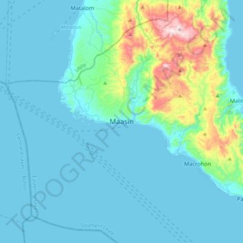
Name: Maasin topographic map, elevation, terrain.

Location: Maasin, Southern Leyte, Eastern Visayas, Philippines (9.97251 124.67851 10.29251 124.99851)

Average elevation: 90 m

Minimum elevation: 0 m

Maximum elevation: 687 m

Gear up for your next adventure:

🥾Mountaineering Boots - Supportive boots for climbing and high-altitude hiking
🧣Merino Neck Gaiter - Protects against wind, sun, and cold at high altitudes
👟Sport Hiking Sandals - Breathable footwear for water crossings and camp rest
🥾Light Hiking Boots - Lightweight and comfortable boots for day hikes
🧦Crew Hiking Socks - Comfortable socks for long-distance hikes

As an Amazon Associate, this site earns from qualifying purchases at no extra cost to you.