Geolocate

Pooc II topographic map

Click on the map to display elevation.

About this map

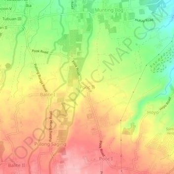
Name: Pooc II topographic map, elevation, terrain.

Location: Pooc II, Silang, Cavite, Calabarzon, 4118, Philippines (14.18125 120.97086 14.22125 121.01086)

Average elevation: 350 m

Minimum elevation: 273 m

Maximum elevation: 412 m

Other topographic maps

Click on a map to view its topography, its elevation and its terrain.

Molino Dam

Philippines > Cavite > Bacoor

Average elevation: 37 m

Rosario

Philippines > Cavite

Average elevation: 3 m

Noveleta

Philippines > Cavite

Average elevation: 2 m

Cavite City

Philippines > Cavite

Average elevation: 53 m

Bacoor River

Philippines > Cavite > Bacoor

Average elevation: 8 m

Tanza

Philippines > Cavite

Average elevation: 28 m

Navarro

Philippines > Cavite > General Trias

Average elevation: 20 m

General Mariano Alvarez

Philippines > Cavite

Average elevation: 128 m

Magallanes

Philippines > Cavite > Magallanes

Average elevation: 198 m

Bacao 2

Philippines > Cavite > General Trias > Bacao 2

Average elevation: 10 m

Alapan II-B

Philippines > Cavite > Imus

Average elevation: 20 m

Gear up for your next adventure:

🔥Camping Stove - Portable stoves to cook outdoors with ease
🥾Hiking Leggings - Comfortable leggings for outdoor activities
🥾Trail Hiking Shoes - Durable shoes designed for rugged trails
🎒Backpack Rain Cover - External shield to keep your entire pack dry
💡LED Camping Lantern - Illuminate your campsite with long-lasting lanterns

As an Amazon Associate, this site earns from qualifying purchases at no extra cost to you.