Geolocate

Pontevedra topographic map

Click on the map to display elevation.

About this map

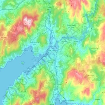
Name: Pontevedra topographic map, elevation, terrain.

Location: Pontevedra, Galicia, Spain (42.34323 -8.69916 42.51306 -8.55511)

Average elevation: 174 m

Minimum elevation: -2 m

Maximum elevation: 607 m

Other topographic maps

Click on a map to view its topography, its elevation and its terrain.

Outeiro do Castro

Spain > Galicia > Pontevedra > Pontevedra > Rosende

Average elevation: 208 m

A Pedreira

Spain > Galicia > Pontevedra

Average elevation: 457 m

Chain

Spain > Galicia > Pontevedra > Ponte Caldelas

Average elevation: 263 m

Gear up for your next adventure:

❄️Traction Ice Cleats - Slip-on spikes for icy trails and winter hiking
🥾Trail Running Boots - Durable shoes designed for trail running
🧥Thermal Fleece Jacket - Versatile insulation for changing mountain temperatures
🧴Outdoor Sunscreen - High SPF protection for high-altitude UV exposure
🕶️Polarized Sunglasses - Reduces glare from snow and water at high elevations

As an Amazon Associate, this site earns from qualifying purchases at no extra cost to you.