Geolocate

Mercer Island topographic map

Click on the map to display elevation.

Mercer Island

Mercer Island City Hall is located at 47°34′39″N 122°12′43.2″W / 47.57750°N 122.212000°W / 47.57750; -122.212000 (47.5775, -122.212). The peak elevation in the city is about 338 feet (103 m), near the center of the island.

Wikipedia (CC-BY-SA 3.0)

About this map

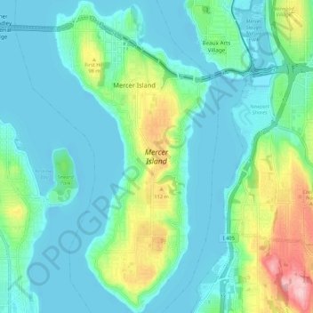
Name: Mercer Island topographic map, elevation, terrain.

Location: Mercer Island, King County, Washington, 98040, United States (47.52443 -122.25452 47.59602 -122.20153)

Average elevation: 39 m

Minimum elevation: -3 m

Maximum elevation: 176 m

Gear up for your next adventure:

🥾Waterproof Hiking Shoes - Durable shoes for wet and rugged trails
🛏️Sleeping Bag - Warm and compact sleeping bags for outdoor camping
🔭Compact Monocular - One-handed bird watching and trail spotting
🧢Outdoor Cap - Protective cap for sun and rain during hikes
🥾Hiking Shorts - Breathable shorts suitable for summer hikes

As an Amazon Associate, this site earns from qualifying purchases at no extra cost to you.