Geolocate

Leuven topographic map

Click on the map to display elevation.

About this map
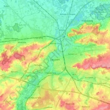
Name: Leuven topographic map, elevation, terrain.

Location: Leuven, Flemish Brabant, Flanders, Belgium (50.82421 4.64030 50.94407 4.77053)

Average elevation: 43 m

Minimum elevation: 4 m

Maximum elevation: 107 m

Other topographic maps

Click on a map to view its topography, its elevation and its terrain.
Leuven

Belgium > Flemish Brabant > Leuven > Leuven

Average elevation: 50 m

Bos

Belgium > Flemish Brabant > Leuven > Zoutleeuw

Average elevation: 31 m

Orsmaal

Belgium > Flemish Brabant > Leuven

Average elevation: 44 m

Optielt

Belgium > Flemish Brabant > Leuven > Tielt

Average elevation: 51 m

Butsel

Belgium > Flemish Brabant > Leuven > Boutersem

Average elevation: 66 m

Beneden-Kessel

Belgium > Flemish Brabant > Leuven > Leuven > Kessel-Lo

Average elevation: 34 m

Ourodenberg

Belgium > Flemish Brabant > Leuven > Aarschot

Average elevation: 16 m

Stadspark

Belgium > Flemish Brabant > Leuven > Aarschot

Average elevation: 24 m

Gear up for your next adventure:

🧦Crew Hiking Socks - Comfortable socks for long-distance hikes
🦯Trekking Poles - Reduced impact on joints for steep topographic climbs
❄️Traction Ice Cleats - Slip-on spikes for icy trails and winter hiking
🥾Hiking Boots - Sturdy boots providing ankle support and traction on rugged trails
🧦Hiking Liner Socks - Thin base layer to prevent friction and blisters

As an Amazon Associate, this site earns from qualifying purchases at no extra cost to you.