
Licking County topographic map
Interactive map
Click on the map to display elevation.
About this map
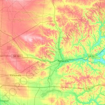
Name: Licking County topographic map, elevation, terrain.
Location: Licking County, Ohio, United States (39.91324 -82.78244 40.27700 -82.18284)
Average elevation: 313 m
Minimum elevation: 227 m
Maximum elevation: 413 m
Other topographic maps
Click on a map to view its topography, its elevation and its terrain.
Black Hand Gorge State Nature Preserve
United States > Ohio > Licking County > Rock Haven Park
Black Hand Gorge State Nature Preserve, Paul Avenue Southeast, Rock Haven Park, Hanover Township, Licking County, Ohio, 43055, United States
Average elevation: 273 m
Newark
United States > Ohio > Licking County
Newark, Licking County, Ohio, 43055, United States
Average elevation: 286 m