Geolocate

Caleao topographic map

Click on the map to display elevation.

About this map

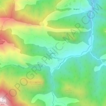
Name: Caleao topographic map, elevation, terrain.

Location: Caleao, Caso, Asturias, Spain (43.13531 -5.43251 43.17531 -5.39251)

Average elevation: 904 m

Minimum elevation: 540 m

Maximum elevation: 1,585 m

Gear up for your next adventure:

🧰Emergency Multi-Tool - Compact multi-tool for outdoor survival
🧥Waterproof Pants - Keep dry during rainy hiking conditions
🧦Hiking Liner Socks - Thin base layer to prevent friction and blisters
🧼Travel Hand Sanitizer - Keep hands clean when water is scarce
🧢Sun Protection Cap - Breathable cap to protect from sun exposure

As an Amazon Associate, this site earns from qualifying purchases at no extra cost to you.