
Thank you for supporting this site ❤️
Make a donation
Make a donation
Gear up for your next adventure:
As an Amazon Associate, this site earns from qualifying purchases at no extra cost to you.
Grantsville topographic map
Click on the map to display elevation.
Thank you for supporting this site ❤️
Make a donation
Make a donation
Gear up for your next adventure:
As an Amazon Associate, this site earns from qualifying purchases at no extra cost to you.
About this map
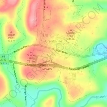
Name: Grantsville topographic map, elevation, terrain.
Location: Grantsville, Garrett County, Maryland, United States (39.68379 -79.16481 39.70820 -79.13626)
Average elevation: 706 m
Minimum elevation: 640 m
Maximum elevation: 763 m
Thank you for supporting this site ❤️
Make a donation
Make a donation
Gear up for your next adventure:
As an Amazon Associate, this site earns from qualifying purchases at no extra cost to you.
Other topographic maps
Click on a map to view its topography, its elevation and its terrain.
Casselman Bridge State Park
United States > Maryland > Garrett County > Grantsville
Average elevation: 696 m