Geolocate

Blake topographic map

Click on the map to display elevation.

About this map

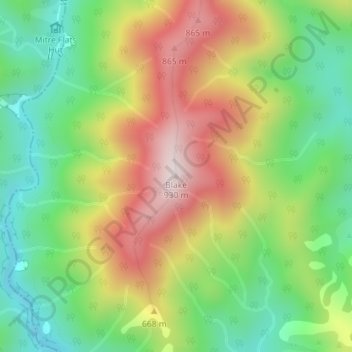
Name: Blake topographic map, elevation, terrain.

Location: Blake, Masterton District, Wellington, New Zealand (-40.84198 175.49092 -40.84188 175.49102)

Average elevation: 568 m

Minimum elevation: 308 m

Maximum elevation: 910 m

Gear up for your next adventure:

🚲Heavy Duty Bike Lock - Secure your bike at the trailhead or during stops
🥽Outdoor Goggles - Protective eyewear for outdoor activities
🧢Sun Protection Cap - Breathable cap to protect from sun exposure
👟Leg Gaiters - Keep debris, mud, and snow out of your boots
🥤Collapsible Travel Cup - Saves space and weight in your mess kit

As an Amazon Associate, this site earns from qualifying purchases at no extra cost to you.