
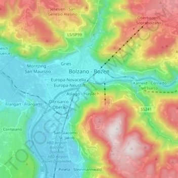
Bolzano - Bozen topographic map
Interactive map
Click on the map to display elevation.
About this map
Name: Bolzano - Bozen topographic map, elevation, terrain.
Average elevation: 675 m
Minimum elevation: 221 m
Maximum elevation: 1,613 m
The area of the city of Bolzano is 52.3 km2 (20.2 sq mi), of which 28 km2 (11 sq mi) is used as a settlement area. The city is located in the basin where the Sarntal, Eisacktal, and the Adige Valley with their rivers, Talfer, Eisack, and Adige, meet. In the Middle Ages, the two main Alpine crossings, the Via Claudia Augusta over Reschenpass and the Brenner route over Brenner Pass, met in Bolzano. Thus, the city was very important for trading. The highest point is 1,616 metres (5,302 feet) above sea level and the lowest point is 232 metres (761 feet) above sea level. The center is located at an altitude of 262 metres (860 feet) above sea level. The nearest big cities are 58 km (36 mi) (Trento) and 118 km (73 mi) (Innsbruck) away.
Other topographic maps
Click on a map to view its topography, its elevation and its terrain.
Stilfs - Stelvio
Italy > Trentino-Alto Adige/Südtirol > South Tyrol
Stilfs - Stelvio, Vinschgau - Val Venosta, South Tyrol, Trentino-Alto Adige/Südtirol, 39029, Italy
Average elevation: 2,419 m
Etsch - Adige
Italy > Trentino-Alto Adige/Südtirol > South Tyrol > Tarnell - Tarnello > Oberplatz
Etsch - Adige, Oberplatz, Tarnell - Tarnello, Laas - Lasa, Vinschgau - Val Venosta, South Tyrol, Trentino-Alto Adige/Südtirol, 39023, Italy
Average elevation: 1,075 m
Eisacktal - Valle Isarco
Italy > Trentino-Alto Adige/Südtirol > South Tyrol
Eisacktal - Valle Isarco, South Tyrol, Trentino-Alto Adige/Südtirol, Italy
Average elevation: 1,487 m
Sëlva - Wolkenstein - Selva
Italy > Trentino-Alto Adige/Südtirol > South Tyrol > Sëlva - Wolkenstein - Selva di Val Gardena
Sëlva - Wolkenstein - Selva, Sëlva - Wolkenstein - Selva di Val Gardena, Salten-Schlern - Salto-Sciliar, South Tyrol, Trentino-Alto Adige/Südtirol, 39048, Italy
Average elevation: 1,828 m
Pens - Pennes
Italy > Trentino-Alto Adige/Südtirol > South Tyrol > Sarntal - Sarentino
Pens - Pennes, Sarntal - Sarentino, Salten-Schlern - Salto-Sciliar, South Tyrol, Trentino-Alto Adige/Südtirol, Italy
Average elevation: 1,850 m
Viums - Fiumes
Italy > Trentino-Alto Adige/Südtirol > South Tyrol > Natz-Schabs - Naz-Sciaves
Viums - Fiumes, Natz-Schabs - Naz-Sciaves, Eisacktal - Valle Isarco, South Tyrol, Trentino-Alto Adige/Südtirol, 39037, Italy
Average elevation: 847 m
Neustift - Novacella
Italy > Trentino-Alto Adige/Südtirol > South Tyrol
Neustift - Novacella, Vahrn - Varna, Eisacktal - Valle Isarco, South Tyrol, Trentino-Alto Adige/Südtirol, 39042, Italy
Average elevation: 777 m
Pfitsch - Val di Vizze
Italy > Trentino-Alto Adige/Südtirol > South Tyrol
Pfitsch - Val di Vizze, Wipptal - Alta Vall'Isarco, South Tyrol, Trentino-Alto Adige/Südtirol, 39049, Italy
Average elevation: 1,953 m
Fleins - Lines
Italy > Trentino-Alto Adige/Südtirol > South Tyrol > Freienfeld - Campo di Trens > Mauls - Mules
Fleins - Lines, Mauls - Mules, Freienfeld - Campo di Trens, Wipptal - Alta Vall'Isarco, South Tyrol, Trentino-Alto Adige/Südtirol, Italy
Average elevation: 1,367 m
Franzensfeste - Fortezza
Italy > Trentino-Alto Adige/Südtirol > South Tyrol > Franzensfeste - Fortezza
Franzensfeste - Fortezza, Wipptal - Alta Vall'Isarco, South Tyrol, Trentino-Alto Adige/Südtirol, 39045, Italy
Average elevation: 1,417 m
Klettergarten Hohe Festung (Franzenfeste)
Italy > Trentino-Alto Adige/Südtirol > South Tyrol > Franzensfeste - Fortezza > Obersalcher
Klettergarten Hohe Festung (Franzenfeste), Obersalcher, Franzensfeste - Fortezza, Wipptal - Alta Vall'Isarco, South Tyrol, Trentino-Alto Adige/Südtirol, 39045, Italy
Average elevation: 1,048 m
Innichen - San Candido
Italy > Trentino-Alto Adige/Südtirol > South Tyrol
Innichen - San Candido, Pustertal - Val Pusteria, South Tyrol, Trentino-Alto Adige/Südtirol, Italy
Average elevation: 1,791 m
Meran - Merano
Italy > Trentino-Alto Adige/Südtirol > South Tyrol
Meran - Merano, Burggrafenamt - Burgraviato, South Tyrol, Trentino-Alto Adige/Südtirol, 39012, Italy
Average elevation: 635 m
Moos in Passeier - Moso in Passiria
Italy > Trentino-Alto Adige/Südtirol > South Tyrol
Moos in Passeier - Moso in Passiria, Burggrafenamt - Burgraviato, South Tyrol, Trentino-Alto Adige/Südtirol, 39013, Italy
Average elevation: 2,082 m