Geolocate

Tupelo topographic map

Click on the map to display elevation.

About this map

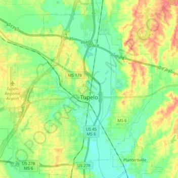
Name: Tupelo topographic map, elevation, terrain.

Location: Tupelo, Lee County, Mississippi, United States (34.20243 -88.80086 34.32413 -88.64969)

Average elevation: 94 m

Minimum elevation: 71 m

Maximum elevation: 130 m

Gear up for your next adventure:

🥾Waterproof Hiking Boots - Boots keeping your feet dry in wet conditions
🚲MTB Frame Bag - Carry tools and maps directly on your bicycle frame
🧳Compression Sacks - Maximize space in your backpack by shrinking gear
📷Outdoor Action Camera - Capture high-elevation views and rugged adventures
🧰Survival Kit - Essential gear for emergencies in the wilderness

As an Amazon Associate, this site earns from qualifying purchases at no extra cost to you.