
Limassol topographic map
Interactive map
Click on the map to display elevation.
About this map
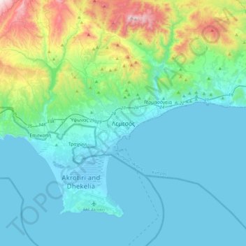
Name: Limassol topographic map, elevation, terrain.
Average elevation: 176 m
Minimum elevation: -5 m
Maximum elevation: 1,046 m
Other topographic maps
Click on a map to view its topography, its elevation and its terrain.
Park of the Fallen & Missing of the Turkish Invasion of 1974
Park of the Fallen & Missing of the Turkish Invasion of 1974, Avgorou, Famagusta District, Cyprus
Average elevation: 39 m
Limassol Salt Lake
Limassol Salt Lake, Michalaki P Neokleous, Asomatos, Limassol, Cyprus, 4645, Cyprus
Average elevation: -2 m