Geolocate

Sturbridge topographic map

Click on the map to display elevation.

About this map

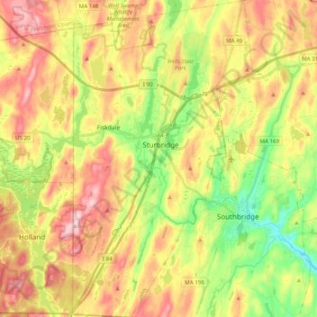
Name: Sturbridge topographic map, elevation, terrain.

Location: Sturbridge, Worcester County, Massachusetts, United States (42.02873 -72.13572 42.17442 -72.02401)

Average elevation: 221 m

Minimum elevation: 113 m

Maximum elevation: 333 m

Other topographic maps

Click on a map to view its topography, its elevation and its terrain.

Gear up for your next adventure:

🩹Moleskin Blister Pads - Direct protection for painful foot pressure points
🥾Hiking Gaiters - Protect legs and shoes from mud, snow, and debris
🏃Hydration Running Vest - Carry water and maps close to your body for speed
🧦Outdoor Socks - Durable socks designed for hiking and outdoor sports
🧥Fleece Jacket - Warm and lightweight jacket for layering

As an Amazon Associate, this site earns from qualifying purchases at no extra cost to you.