
Tulsa topographic map
Click on the map to display elevation.
Tulsa
Tulsa is located in the northeastern corner of Oklahoma between the edge of the Great Plains and the foot of the Ozarks in a generally forested region of rolling hills. The city touches the eastern extent of the Cross Timbers, an ecoregion of forest and prairie transitioning from the drier plains of the west to the wetter forests of the east. With a wetter climate than points westward, Tulsa serves as a gateway to "Green Country", a popular and official designation for northeast Oklahoma that stems from the region's green vegetation and relatively large number of hills and lakes compared to central and western areas of Oklahoma, which lie largely in the drier Great Plains region of the Central United States. Located near the western edge of the U.S. Interior Highlands, northeastern Oklahoma is the most topographically diverse part of the state, containing seven of Oklahoma's 11 eco-regions and more than half of its state parks. The region encompasses 30 lakes or reservoirs and borders the neighboring states of Kansas, Missouri, and Arkansas.
About this map
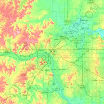
Name: Tulsa topographic map, elevation, terrain.
Location: Tulsa, Tulsa County, Oklahoma, United States (35.96830 -96.07448 36.33651 -95.68160)
Average elevation: 221 m
Minimum elevation: 166 m
Maximum elevation: 321 m
Other topographic maps
Click on a map to view its topography, its elevation and its terrain.