Geolocate

Cardiff topographic map

Click on the map to display elevation.

About this map
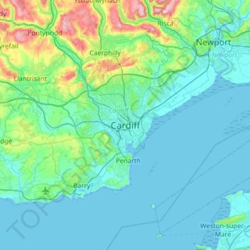
Name: Cardiff topographic map, elevation, terrain.

Location: Cardiff, Wales, CF10 2AF, United Kingdom (51.32165 -3.33919 51.64165 -3.01919)

Average elevation: 55 m

Minimum elevation: 0 m

Maximum elevation: 417 m

Other topographic maps

Click on a map to view its topography, its elevation and its terrain.
Dipping Pond

United Kingdom > Wales > Cardiff > Cardiff

Average elevation: 50 m

Gear up for your next adventure:

🚲Bike Repair Kit - Essential tools for on-trail mechanical issues
🥾Approach Shoes - Shoes designed for climbing approaches and rugged trails
🧴Waterproofing Spray - Restore the DWR coating on jackets and tents
🧥Packable Rain Jacket - Breathable waterproof layer for unpredictable weather
💧Hydration Bladder - Hands-free hydration solution for long treks

As an Amazon Associate, this site earns from qualifying purchases at no extra cost to you.