
Make a donation
Gear up for your next adventure:
As an Amazon Associate, this site earns from qualifying purchases at no extra cost to you.
Town of Rothesay topographic map
Click on the map to display elevation.
Make a donation
Gear up for your next adventure:
As an Amazon Associate, this site earns from qualifying purchases at no extra cost to you.
About this map
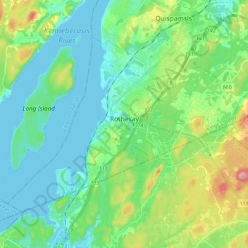
Name: Town of Rothesay topographic map, elevation, terrain.
Location: Town of Rothesay, Kings County, New Brunswick, Canada (45.33785 -66.06581 45.41924 -65.90010)
Average elevation: 51 m
Minimum elevation: -9 m
Maximum elevation: 197 m
Kings County trails, hiking, mountain biking, running and outdoor activities
Make a donation
Gear up for your next adventure:
As an Amazon Associate, this site earns from qualifying purchases at no extra cost to you.
Other topographic maps
Click on a map to view its topography, its elevation and its terrain.
Make a donation
Gear up for your next adventure:
As an Amazon Associate, this site earns from qualifying purchases at no extra cost to you.
Grand Bay - Westfield
Canada > New Brunswick > Kings County > Grand Bay-Westfield > Grand Bay - Westfield
Average elevation: 53 m
Make a donation
Gear up for your next adventure:
As an Amazon Associate, this site earns from qualifying purchases at no extra cost to you.