Geolocate

Orea topographic map

Click on the map to display elevation.

About this map
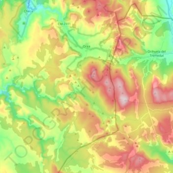
Name: Orea topographic map, elevation, terrain.

Location: Orea, Señorío de Molina, Guadalajara, Castile-La Mancha, 19311, Spain (40.45105 -1.78451 40.59503 -1.68964)

Average elevation: 1,603 m

Minimum elevation: 1,338 m

Maximum elevation: 1,926 m

Other topographic maps

Click on a map to view its topography, its elevation and its terrain.
Gear up for your next adventure:

🥽Outdoor Goggles - Protective eyewear for outdoor activities
🌡️Emergency Mylar Blankets - Compact thermal protection for unexpected nights outdoors
👟Sport Hiking Sandals - Breathable footwear for water crossings and camp rest
🔨Vehicle Emergency Tool - Safety tool for remote road trips to trailheads
🧴Sunscreen SPF - Broad-spectrum sunscreen for outdoor activities

As an Amazon Associate, this site earns from qualifying purchases at no extra cost to you.