Geolocate

Wetherby topographic map

Click on the map to display elevation.

About this map

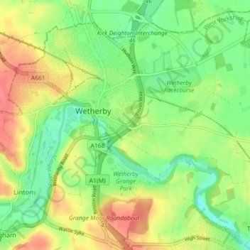
Name: Wetherby topographic map, elevation, terrain.

Location: Wetherby, Leeds, West Yorkshire, England, United Kingdom (53.90615 -1.41069 53.94587 -1.33983)

Average elevation: 35 m

Minimum elevation: 9 m

Maximum elevation: 66 m

Gear up for your next adventure:

🥾Mountain Hiking Boots - High-traction boots for rocky terrain
💧Collapsible Water Bottle - Space-saving water bottle for outdoor activities
🔥Emergency Fire Starter - Reliable ignition source for all weather conditions
🎒Hiking Daypack - Lightweight and durable backpacks for day trips and excursions
💧Hydration Pack - Hands-free hydration system for long hikes

As an Amazon Associate, this site earns from qualifying purchases at no extra cost to you.