
Roaring River topographic map
Click on the map to display elevation.
About this map
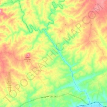
Name: Roaring River topographic map, elevation, terrain.
Location: Roaring River, Wilkes County, North Carolina, United States (36.20150 -81.09593 36.29628 -81.00849)
Average elevation: 362 m
Minimum elevation: 278 m
Maximum elevation: 448 m
Other topographic maps
Click on a map to view its topography, its elevation and its terrain.
Stone Mountain State Park
United States > North Carolina > Wilkes County
The centerpiece of the park is Stone Mountain, a dome of exposed granite (specifically a quartz diorite to granodiorite) of Devonian age, which has intruded into the gneiss of the Precambrian Alligator Back Formation. It rises sharply over 600 feet (183 m) above the surrounding terrain. The mountain, which has…
Average elevation: 641 m