Geolocate

Pray topographic map

Click on the map to display elevation.

About this map

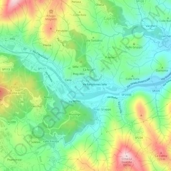
Name: Pray topographic map, elevation, terrain.

Location: Pray, Biella, Piedmont, 13867, Italy (45.65654 8.18519 45.69369 8.23472)

Average elevation: 518 m

Minimum elevation: 388 m

Maximum elevation: 761 m

Other topographic maps

Click on a map to view its topography, its elevation and its terrain.

Valle Mosso

Italy > Piedmont > Biella

Average elevation: 592 m

Cà Nova

Italy > Piedmont > Biella > Pray

Average elevation: 525 m

Gear up for your next adventure:

🔭Compact Monocular - One-handed bird watching and trail spotting
💧Filtered Water Bottle - Safe drinking water on the go
🦶Anti-Blister Balm - Prevents friction and hotspots during long ascents
🧴Insect Repellent - Protect yourself from bugs during outdoor adventures
🧥Waterproof Hiking Jacket - Protect yourself from rain and wind while hiking

As an Amazon Associate, this site earns from qualifying purchases at no extra cost to you.