
Make a donation
Gear up for your next adventure:
As an Amazon Associate, this site earns from qualifying purchases at no extra cost to you.
Aburi topographic map
Click on the map to display elevation.
Make a donation
Gear up for your next adventure:
As an Amazon Associate, this site earns from qualifying purchases at no extra cost to you.
Aburi
Due to the altitude of Aburi, the climate is a lot cooler than neighbouring Accra. The road which climbs the hillside to Aburi is a toll road, with the current toll being 0.50 Ghc for a car, 1.00 Ghc for a 4x4.
Make a donation
Gear up for your next adventure:
As an Amazon Associate, this site earns from qualifying purchases at no extra cost to you.
About this map
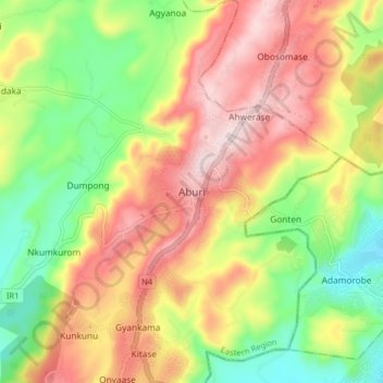
Name: Aburi topographic map, elevation, terrain.
Location: Aburi, Akuapim South District, Eastern Region, Ghana (5.80748 -0.21527 5.88748 -0.13527)
Average elevation: 277 m
Minimum elevation: 88 m
Maximum elevation: 478 m
Make a donation
Gear up for your next adventure:
As an Amazon Associate, this site earns from qualifying purchases at no extra cost to you.